Herramientas/Tool Index
Urban Land Valuation
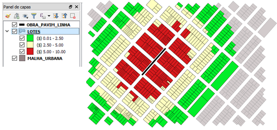
This model was developed to visualize how a public works project could affect the valuation of nearby lots. It helps predict the continuous appreciation of the land using data from real estate market observatories, with samples of historical market prices before and after the completion of a work, using data nearby and up to the limit of evidence of its influence. From the comparison of prices before and after, a map of the differences is generated by visualizing the magnitude of the changes in value in each lot.
The ranges of values were established based on the distance from the properties to the work. These values were introduced in the complement to allow other municipalities to perform or predict the valuation of properties around similar work.
This tool was implemented in Brazil within the framework of the RG-T3099 project “Digital Solutions for Local Taxation” (https://www.iadb.org/es/project/RG-T3099).

